

Community overview
The City of Vergennes was incorporated in 1788 in order to form a single jurisdiction over the falls of Otter Creek, which at the time was at the junction of four towns. Vergennes has now grown to a population of approximately 2,700, but still retains some open space within the 2.4 square-mile city boundaries. After the opening of the Champlain Canal in 1823, Vergennes was connected to New York City via the Hudson River and to points west via the Erie Canal. The city profited from the export of lumber and farm products, and the falls became a center of manufacturing. Like much of Vermont, Vergennes experienced a slump in the first half of the 20th century. Over the past couple of decades, though, Vergennes has made a remarkable recovery from the poverty and disinvestment that defined the postwar era. With the restoration of the Opera House as the centerpiece, the downtown streetscape has come back to life. New retail businesses now fill the downtown, and property values have risen considerably. Goodrich Corp. is now a major local employer, and the Burlington area is a reasonable commute away.
Tools you can use
In trying to determine the key design components of Vermont’s traditional neighborhoods, volunteers and staff at Smart Growth Vermont documented various dimensional and design components of existing neighborhoods in Bristol, Vergennes, Orwell and Burlington. Thus, these case studies are a bit different than other case studies in this Toolbox. They document existing features so town planners can easily visualize a traditional neighborhood layout that is often more compact than their current regulations may allow. We encourage communities to document their own historic neighborhoods, or use these case studies as a guide when updating your town’s planning regulations. Communities can visit these case study communities and gain a visual idea of how these standards play out on the ground. Many Vermont communities could not replicate the town centers in their community under current zoning bylaws. Is this true for your community?
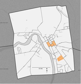
Area Studied in Vergennes

Vergennes’ residential areas reflect the changing fortunes of the city across 220 years. Its oldest houses were built during a short-lived economic boom in the early 1800s, fueled by an iron foundry and the production of ships for the War of 1812. The late 1800s saw Vergennes bustling with factories producing numerous wood products as well as leather, flour and horseshoe nails. During this time, the city put in sidewalks and shade trees for the growing residential areas, and entrepreneurs built out the downtown business blocks. Vergennes remains a vibrant downtown with farmer’s markets, restaurants, a town green and opera house within easy walking distance to residential neighborhoods.
As part of the “Traditional Vermont Neighborhoods” project, Smart Growth Vermont studied three blocks in the older part of the city and one (Sunset Drive) that was built primarily in the 1960s. Vergennes’ neighborhoods have densities and styles to please all tastes. The earliest houses were built right up to the street and are intermixed with businesses. The second wave of homes has small front yards and a mix of single-family and multi-family structures. The most recent neighborhoods are built on a more suburban template, with large yards and no multi-family housing.
Density in the study area varies from three to nine units per acre. Lot sizes, lot depth, setbacks and house sizes vary from street to street (View the summary table). Average lot sizes range from about .17 to .3 acres; width range from 69 to 101 feet.
The older blocks are in Vergennes’ residential historic district. Here it is easy and pleasant to walk downtown past houses with interesting architecture and a variety of types and sizes. Sunset Drive is walkable as well, although there are fewer nearby destinations and no alternate routes, since the street is a loop. The land use is more homogeneous, with single family homes of relatively similar design and no apartments or businesses.
Details of Blocks Studied in Vergennes
Block One: bounded by King Street, South Maple Street, Short Street and Green Street.
This block has a net density of 9.3 units per acre and a range of lot widths of 40 to 95 ft. and the range of living area is from 768 to 4,556 sq ft. which provides options for people at different life stages and income levels. This block also contains:
- 7 single-family homes
- 5 duplexes
- one 3-unit apartment
Block Two: bounded by Roberts Street, South Water Street, School Street and Maple Street.
This block has a net density of 6.4 units per acre and a range of lot widths of 45-130 feet and a range of living area is from 1,500 to 3,900 sq ft. and contains a mix of uses as well. This block also contains:
- 10 single family homes
- 4 duplexes
- one 3-unit apartment
- one 4-unit apartment
- one in-home dental office
- one funeral home with apartment
- 22 single family lots
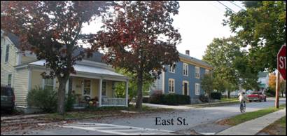
Block Three: bounded by New Haven Street, Green Street, Short Street and East Street.
This block has a net density of 4.8 units per acre and a range of lot widths of 55 to 145 feet and total living area that ranges from 802 to 4,834 sq. ft. The range in housing sizes offer options for those that live in the community. This block has only residents:
- 13 single family homes
- two duplexes
Block Four: bounded by Sunset Drive.
This block, while close to downtown, is a more suburban layout. However, unlike many suburban style developments, there is a range of housing sizes and styles. It has a net density of 3.3 and a range of lot widths between 70 and 135 feet and living area that ranges between 864 and 2436 sq. ft. This block only has 25 single family homes.