


Community overview
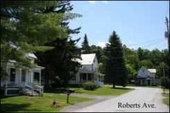
Venture east on Route 73 at its intersection with Route 22A in southern Addison County and you will discover lovely Orwell Village. The beautiful town hall, church, library and bank, surrounding a charming green and homes, along with the school, general store and a variety of other shops create a true feeling of home. Like many villages in Vermont, Orwell grew rapidly in the early 1800s, then very little over the next two centuries. Its grand buildings are a legacy of the merino sheep boom and of the opening of the Champlain Canal in 1832. Despite its small size – the entire town, which extends to the shores of Lake Champlain, had a population of 1,182 in the year 2000 – Orwell has been able to maintain its civic and commercial heart.
Tools you can use
In trying to determine the key design components of Vermont’s traditional neighborhoods, volunteers and staff at Smart Growth Vermont documented various dimensional and design components of existing neighborhoods in Bristol, Vergennes, Orwell and Burlington. Thus, these case studies are a bit different than other case studies in this Toolbox. They document existing features so town planners can easily visualize a traditional neighborhood layout that is often more compact than their current regulations may allow. We encourage communities to document their own historic neighborhoods, or use these case studies as a guide when updating your town’s planning regulations. Communities can visit these case study communities and gain a visual idea of how these standards play out on the ground. Many Vermont communities could not replicate the town centers in their community under current zoning bylaws. Is this true for your community?
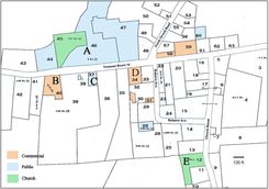
Area Studied in Orwell
The irregular lot shapes in the village center are the result of large parcels being incrementally subdivided over the years, producing a unique pattern that would be difficult to duplicate in a new development. Many yards are quite deep, but the houses are not hidden away. Instead, they are almost all located fairly close to the street. This makes for an attractive and welcoming streetscape that promotes walkability and easy interaction among neighbors. Churches and the library are interspersed with residential lots and the mixture of civic and commercial uses is notable. Post offices, libraries, schools, and town halls draw people who have necessary business at these places. Once in town, they are likely to go next door or across the street to shop or have a bite to eat. Although Orwell is very small, it is just large enough to see that synergistic effect.
As part of the “Traditional Vermont Neighborhoods” project, Smart Growth Vermont studied a cluster of properties within walking distance of the main intersection at the center of the village (view map). Although there are other compact clusters of homes in the town of Orwell (such as along nearby lakes), those areas do not have the mix of uses.
Orwell village, small as it is, demonstrates many principles that apply in larger towns and even big city neighborhoods: relatively narrow lots and short setbacks, a mix of uses, pedestrian friendly streets, and human scale buildings; that is, buildings that are designed to be inviting at close range, not just recognizable to motorists passing at 60 mph. These elements combine to produce a walkable, appealing community that holds its value and attracts residents over the long haul.
The overall densities in Orwell would be smaller (less units per acre) than our other case study communities because the village has some very large lots – some almost 6 acres. However, the location of the buildings on the lots, the mixture of uses and architectural variety are consistent with a traditional Vermont neighborhood. Residences are on varying size lots, some quite large, but lot widths and setbacks are small enough to make the streets walkable and neighborly.
Detail of Blocks Studied in Orwell
For the 44 residential lots we studies the average residential lot frontage was 137 feet, but ranged between 51 to 308 feet. The average setback from the centerline of the street was 43 feet, and ranged from 19 to 121 feet.
There are several key services within easy walking distance that can be seen on this map including the town hall (A), bank (B), library (C), corner store (D), and church (E).